


Hast Du auch Garmin-SW auf dem N95 laufen? (und wie damit zufrieden?)
Wie lange hält der Akku?
Beiträge von freeday
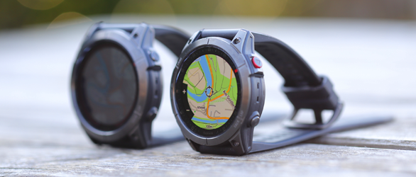
Garmin fenix 7X und epix Gen 2 im Test
Der Schwerpunkt dieses Tests und Vergleichs der Garmin Fenix 7X Solar und Garmin Epix Gen 2 liegt auf den Sensoren wie Höhenmesser, Positionsbestimmung und Herzfrequenz. Was unterscheidet die beiden GPS-Outdoor-Smartwatches? Und wie gut ist die Taschenlampe der Fenix 7X für den Outdoorbereich?
Hier geht es zum Test der Outdoor-Smartwatches ...
-
-
doch ist ein BUG
wenn ich in Profil A eingeschaltet habe und
in Profil B ausgeschaltetdann soll es gefälligst je nach Profil eingestellt werden.
wahr ist aber, daß es nach welcher Konstellation auch immer (bin kein Betatester für Garmin) dann dauernd in beiden Profilen ausgeschaltet ist.
Also ein Bug. -
Der Fehler ist uralt. Der wurde doch schon von Wochen/Monaten bei http://garmincolorado.wikispaces.com beschrieben.
Also wird GARMIN schon daran arbeiten.
mfg
JLacky
uralt ist richtig
Garmin wird daran arbeiten - daran habe ich mittlerweile ernsthaft meine Zweifel.Auf Grund der vielen zufriedenen User werden sie eventuell kein FW-Update mehr machen - ist ja eine Minderheit welche Fehler bemängelt.
-
Wem oder was du auch immer hinterherläufst :D, wenn du die Trackaufzeichnung eingeschaltet hast, wird der zurückgelegte Weg aufgezeichnet.
aber immer kontrollieren - die schaltet sich gerne mal aus beim Profilwechsel - einer der unzähligen Bugs -
Version 1.1.0 of Moagu has been released
http://www.mediafire.com/?jx1gmmzmn11
Changes & enhancements:
- Two more data levels, 0.5-mile and 0.8-mile/1.2-mile.
These will probably be the last data levels added; smaller scales don't make sense, given the limited size of the GPS display. You'd be better off printing a paper map for those.- "Combine points" option added to reduce filesize and increase display speed
Points with the same color are now "combined" together, resulting in performance improvements for most maps. The degree of improvement will depend on the type of map, and how colors are arranged on them; the more areas with adjacent points that have the same color, the better the improvement will be. For USGS topo maps, the improvement in draw speed is fairly small, only about 10%, but I hope to improve this in the future. However, even this small improvement has dramatically reduced map display lag times for topo maps at mountain biking speeds. Black-and-white aerial imagery display times are reduced by as much as a third, because of their limited color palette. Color images that have large areas with the same color should see an improvement as well. File sizes are also smaller, by as much as about one-third. You also have the option to turn this feature off if it creates artifacts in your images.- Load GeoTiff option added to simplify import process for GeoTiffs
Have you gotten annoyed by the need to first read in a GeoTiff file to see the metadata, then re-project it and extract the worldfile, then load each in separately? Well, now the program lets you load in a GeoTiff, does the re-projection automatically, then loads the re-projected image and worldfile directly into the program. This works perfectly for USGS Seamless Server imagery; for other data sources, you should double-check the final results to make sure the map is correct. The re-projection utility is still there if you need it.- Combined Load Map/Worldfile
If you have an image with a worldfile, you only have to click one button; Moagu will start up the file selection windows for both the image and the worldfile automatically.- Only one TYP file is created and loaded for every data level.
Early experiments convinced me that every map tile required its own corresponding TYP file. Stan Kozicki, the author of cgpsmapper, told me that wasn't necessary, and I've found that to be the case. So now, only one TYP file is created for every data level, which can reduce the total file size by as much as 5-10%.- SendMap Pro replaces the free version of SendMap
Stan was also nice enough to offer a free version of SendMap Pro for distribution with Moagu. This is normally a $30 value, so you've essentially saved more than the cost of Moagu with this :). Check the help file for some info on what SendMap Pro can do. Thanks to this new capability, the mapset Map Name is now embedded in every file created by Moagu using SendMap, i.e. the .img and .exe files generated at the end of the process.- Helpfile sections on adding Moagu maps to MapSource, working with data levels
Check the "Advanced Moaguology" section of the help file for a step-by-step description of how to add Moagu maps to MapSource, and how to view them there. This will simplify the job of uploading both Moagu and standard vector maps to your Garmin. If you upload maps to a card in a card reader (see the help file for info on this), you can dramatically reduce the amount of time required to upload large Moagu mapsets to your Garmin. There's also a section with more information on how data levels work with Garmin GPS units, and how to take advantage of that.- Shell commands for creating directories, using SendMap improved
If Moagu has been working for you, you won't notice this, but for those who have had problems, this should fix the remaining issues- Only creates directories for levels that will be used
Moagu used to create directories for every data level, regardless of whether data was being generated for that level or not. Now, with the increased number of available data levels, I've changed that so that only the needed directories will be created.- Added scale to data level indications
I had a table of map scale (for a 60Cx or 76Cx unit) for every data level in the help file, but these are now listed on the main program screen.- Cautionary message that uploading map will delete data currently in the Garmin.
Some people didn't realize that uploading a new mapset to a Garmin erases the previous one; the pop-up message now makes that clear before you upload a mapset to your Garmin using Moagu. -
...
Ist die Macht der Gewohnheit, der Griff zum Gurt kommt vor dem Dreh am Zündschlüssel, geht ganz automatisch.Schöne Grüße,
Bernd
Das freut mich zu hören - war auch nicht böse gemeint, sondern aus reinem Interesse gefragt. (hätte ich also auch gefragt, wenn ich mal erwachsen werden sollte) -
na das hört sich fein an - Danke
-
den Anhang kann ich nicht lesen
-
Hallo Günther!
ich meine damit nicht direkt WM6 sondern die Gps-Schnittstelle.
Da dürfte es noch Probleme beim Umschalten zw. den Applikationenn mit dem Satfix geben.
(...sagt einer der das Gerät nicht selber besitzt, aber sich auch nicht gleich alles kauft was neu ist, weil er mit dem Co schon eine Erfahrung mehr hat :()@Anton Mein Finanzminister meint es ist sowieso sinnlos

was aber kein Grund ist gleich loszuschlagen.
Bis jetzt konnte ich leider noch nicht feststellen, daß seit der eXploristenzeit eine Trendwende Support/Bugfix eingetreten ist. -
Das Akkusystem und ipx7 (wenn es besser als das ipx7 des CO ist) würde mir sehr gut gefallen.
mal sehen wie der Marktpreis nach einiger Zeit sein wird....und wie der FW-Support ist. -
Alles anzeigen
Was soll den das Geschwätz !
Wie soll eine Hardware eine Softwaresperre aufheben ?
Meist du Magellan macht sowas, weil es rechtlich unbedenklich ist ?
Denken hilft !
Auf dem MM6 laufen (fast) alle WindowsMobile-Anwendungen !
Also auch euer geliebtes XT.Erst mal Informieren.
Lesen hilft hier oft !
Hallo Ziploader!Ich lass mir gerne auf den Kopf werfen, man solle zuerst die Suchfunktion verwenden wenn es hier im Forum steht.
Aber wenn es im WWW eine Adresse ist, dann finde ich diesen Vorwurf von Dir schon eigenartig.
Zumindest habe ich Dich nun aufgrund Deiner Wortwahl besser kenngelernt.Mit noch freundlichen Grüssen
-
ist zwar OT aber das interessiert mich jetzt wirklich:
Wenn Du 100 Meter mit dem Auto fährst, gurtest Du Dich dann an? (ehrliche Antwort bitte) -
also mit der aktuellen FW/sW-Version ist das gpsmap60csx das Beste was ich je gesehen habe
habs schon am 7.3.2008 erwähnt
http://www.naviboard.de/vb/showpost.php?p=198664&postcount=9 -
Informier Dich mal über den Magellan MobileMapper 6, da bräuchstest Du noch nicht einmal deine Garmin Karten zu entsorgen.
VG
Sockeye
soll das heissen man kann die gesperrten Garmin-Karten dann problemlos im Triton verwenden? -
ich kenne jetzt einen - weiß aber nicht wie er aussieht
-
machst Du morgen 38 Touren oder eine - das habe ich nicht verstanden

-
DIE GPS-Grundlage:
http://kanadier.gps-info.de/d-gpshandbuch.htm
:8:8:8
(bin nicht verwandt oder bekannt) -
Bernd, das hast jetzt Du gesagt und nicht ich

-
Hallo Alfred!
Hast Du das schon gelesen?
http://www.garmin.at/show_beri….php?ber_id=2271&fpid=372
http://www.garmin.at/_uploads/_elements/2271_file1.pdfGlaube, manche Geräte können es auch schon mit der aktuellsten FW.
-
such mal die Wegpunkte nach nearest und nicht nach symbol